Toggle navigation
PDFSEARCH.IO
Document Search Engine - browse more than 18 million documents
Sign up
Sign in
Back to Results
First Page
Meta Content
View Document Preview and Link
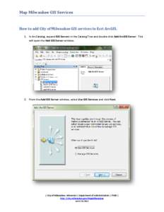
Map Milwaukee GIS Services How to add City of Milwaukee GIS services to Esri ArcGIS. 1. In ArcCatalog, expand GIS Servers in the Catalog Tree and double-click Add ArcGIS Server. This will open the Add GIS Server window.
Add to Reading List
Document Date: 2013-05-31 11:34:44
Open Document
File Size: 586,76 KB
Share Result on Facebook
 Map Milwaukee GIS Services How to add City of Milwaukee GIS services to Esri ArcGIS. 1. In ArcCatalog, expand GIS Servers in the Catalog Tree and double-click Add ArcGIS Server. This will open the Add GIS Server window.