<--- Back to Details
| First Page | Document Content | |
|---|---|---|
 Date: 2009-07-28 16:59:28United States Army Corps of Engineers Mississippi Valley Division Mississippi Geography of the United States United States Mississippi River |
Add to Reading List |
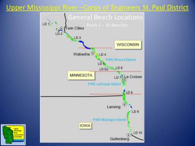
 | Upper Mississippi River –Corps of Engineers St. Paul District General Beach Locations LD 1 Pools 1 – 10 Beaches LD 2DocID: 1rt1a - View Document |
 | Technical Report M55 Montgomery Point Lock and Dam HSR MODEL White River Miles 4.0 – 0.0 HYDRAULIC SEDIMENT RESPONSE MODEL INVESTIGATIONDocID: 1qz8R - View Document |
 | Microsoft Word - Janmin.docDocID: 1qitG - View Document |
 | Upper Mississippi River –Corps of Engineers St. Paul District General Beach Locations LD 1 Pools 1 – 10 Beaches LD 2DocID: 1ppNI - View Document |
 | https://navnotices.usace.army.mil/apex_lpmw/print_nav_notice?inDocID: 1oorw - View Document |
 Microsoft PowerPoint[removed]BGWalsh 200year visionno Macros.ppt [Compatibility Mode]