 Date: 2015-04-08 16:04:03
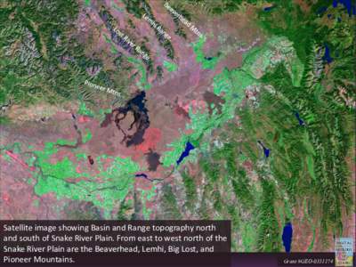
| |  Satellite image showing Basin and Range topography north and south of Snake River Plain. From east to west north of the Snake River Plain are the Beaverhead, Lemhi, Big Lost, and Pioneer Mountains. Grant #GEO Satellite image showing Basin and Range topography north and south of Snake River Plain. From east to west north of the Snake River Plain are the Beaverhead, Lemhi, Big Lost, and Pioneer Mountains. Grant #GEO
Add to Reading ListSource URL: geology.isu.eduDownload Document from Source Website File Size: 2,08 MBShare Document on Facebook
|