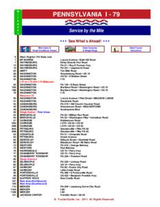
 Date: 2013-12-10 13:00:13Clarion River Clarion County Pennsylvania East Branch Clarion River Lake Mill Creek Pennsylvania Route 68 Cook Forest State Park Clear Creek State Forest Pennsylvania Route 949 Brookville Pennsylvania Geography of Pennsylvania Pennsylvania Wild and Scenic Rivers of the United States | |  Clarion River Public Access Sites—Middle Section River Miles are used to identify the locations of various sites along the river. River Mile 0 is at the confluence of the Clarion River and the Allegheny River. "River L Clarion River Public Access Sites—Middle Section River Miles are used to identify the locations of various sites along the river. River Mile 0 is at the confluence of the Clarion River and the Allegheny River. "River L
Add to Reading ListSource URL: www.fish.state.pa.usDownload Document from Source Website File Size: 1,45 MBShare Document on Facebook
|
![[removed]Vol. 68, No. 809 January-February 2009](https://www.pdfsearch.io/img/060f7357869e1e393c0c5d1dfea4ce93.jpg "[removed]Vol. 68, No. 809 January-February 2009")
![[removed]Vol. 68, No. 814 November-December 2009](https://www.pdfsearch.io/img/b82631acb3d6ccbf96830a148aa10f88.jpg "[removed]Vol. 68, No. 814 November-December 2009")

