<--- Back to Details
| First Page | Document Content | |
|---|---|---|
 Date: 2009-08-04 00:37:33Measurement Orthometric height Vertical deflection Dynamic height Datum Geoid Physical geodesy Gravity gradiometry Above mean sea level Geodesy Geophysics Cartography |
Add to Reading List |
 The GRAV-D Project: Gravity for the Redefinition of the American Vertical Datum A NOAA contribution to the Global Geodetic Observing System (GGOS) component of the Global Earth Observation
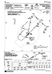 | LKMT ADOSTRAVA/Mošnov RNAV (GNSS) RWYJUL 16DocID: 1rtUq - View Document |
Precise Survey of Reference Points at CrustalDocID: 1qeLx - View Document | |
 | Accepted Manuscript This is a PDF file of a manuscript that has been peer reviewed and accepted for publication. Please note that the article has neither been copy edited nor formatted in the Geofizika style yet, and, thDocID: 1q80Q - View Document |
 | NOTICE OF UNIVERSITY ORAL GEODESY AND GEOMATICS ENGINEERING Master of Science in EngineeringDocID: 1q6oF - View Document |
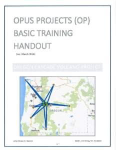 | (ver. Marchp. 1 p. 2DocID: 1pJax - View Document |