<--- Back to Details
| First Page | Document Content | |
|---|---|---|
 Date: 2015-03-30 21:29:08West Greenwich Rhode Island Eastern United States Richmond Rhode Island East Coast of the United States Wood River Woonasquatucket River Flood Geography of the United States Exeter Rhode Island Rhode Island |
Add to Reading List |
 | Wood-Pawcatuck Watershed Association 203 Arcadia Road Hope Valley, RI9017 www.wpwa.org Who wouldn’t want to spend the day on the Wood River?DocID: 1viVN - View Document |
 | WOOD-PAWCATUCK WATERSHED ASSOCIATION PAWCATUCK RIVER: BISCUIT CITY LANDING TO CRONAN FISHING ACCESS LEVEL Intermediate/AdvancedDocID: 1uPM2 - View Document |
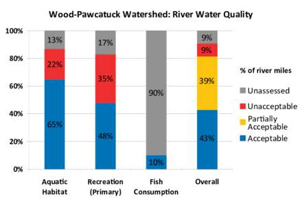
 | Wood-Pawcatuck Watershed: River Water Quality 100% 80% 13% 22%DocID: 1uNmx - View Document |
Wood Pawcatuck Watershed Association To Protect and Preserve the Lands and Waters of the Wood Pawcatuck Watershed Upper Pawcatuck River Fish Passage Restoration ProjectDocID: 1uuqw - View Document | |
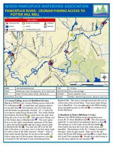
 | WOOD-PAWCATUCK WATERSHED ASSOCIATION PAWCATUCK RIVER: CRONAN FISHING ACCESS TO POTTER HILL MILL MAP LEGEND WATER ACCESSDocID: 1u0y3 - View Document |
 Microsoft Word - Impact of 2010 flood