<--- Back to Details
| First Page | Document Content | |
|---|---|---|
Date: 2015-07-23 13:44:55Hiking Trail Catskill High Peaks Long-distance trails in the United States Shandaken New York Blue-Blazed Trails |
Add to Reading List |
| First Page | Document Content | |
|---|---|---|
Date: 2015-07-23 13:44:55Hiking Trail Catskill High Peaks Long-distance trails in the United States Shandaken New York Blue-Blazed Trails |
Add to Reading List |
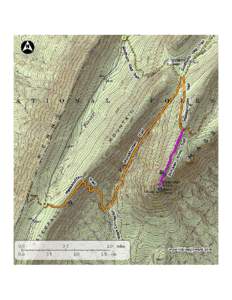
 Start at Fox Hollow Rd. Run up Blue Blazed Giant Ledge-Panther-Fox Hollow Trail 4.9 mi - Climb over a couple of bumps up to summit of Panther Mtn. (2300 ft. ascentmi - Go down and back up to Giant Ledge, gre