<--- Back to Details
| First Page | Document Content | |
|---|---|---|
 Date: 2006-12-12 10:41:18Geometry Geodesy Navigation Mercator projection Map projection Rhumb line Scale Stereographic projection Latitude Cartography Cartographic projections Conformal mapping |
Add to Reading List |
 Basic Geodesy Issue 10 Mercator Projection Roger Foster, Kurt Schulz, and Craig Rollins Coordinate System Analysis Team (CSAT)
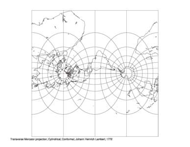 | Transverse Mercator projection; Cylindrical; Conformal; Johann Heinrich Lambert; 1772DocID: 1uegf - View Document |
 | MERCATOR PROJECTION OF THE WORLDKmDocID: 1ubQu - View Document |
 | Mercator projection WGS-84 MarchDONETDocID: 1sxTV - View Document |
 | Mercator projection WGS-84 MarchDONETDocID: 1sky2 - View Document |
 | NEW MAP PROJECTION PARADIGMS: Bresenham Poly-Azimuthal Fly-Through Projections, Oblique Mercator Triptiks, and Dynamic Cartograms Alan Saalfeld Department of Civil and Environmental Engineering and Geodetic Science The ODocID: 1rPEb - View Document |