<--- Back to Details
First PageDocument Content
Florida state parks / Tallahassee metropolitan area / Sirenians / St. Marks River / Wakulla Springs / Wakulla River / Edward Ball Wakulla Springs State Park / San Marcos de Apalache Historic State Park / Fort Ward / Geography of Florida / Florida / Outstanding Florida Waters
Date: 2013-12-16 14:34:35
Florida state parks
Tallahassee metropolitan area
Sirenians
St. Marks River
Wakulla Springs
Wakulla River
Edward Ball Wakulla Springs State Park
San Marcos de Apalache Historic State Park
Fort Ward
Geography of Florida
Florida
Outstanding Florida Waters

Microsoft Word - Wakulla River Trip Planning revised March 2012

Add to Reading List

Source URL: www.dep.state.fl.us

Download Document from Source Website

File Size: 763,52 KB

Share Document on Facebook

Similar Documents

http://www.1000friendsofflorida.org/water/Wakulla%20Restoration

http://www.1000friendsofflorida.org/water/Wakulla%20Restoration

DocID: 1lGR4 - View Document

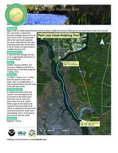
Port Leon Loop Paddling Trail  Overview: Begin at the St. Marks Riverfront Park and Boat Ramp. Paddle downstream following the left (east) bank of the river to access Port Leon Creek. Explore this beautiful winding cours

Port Leon Loop Paddling Trail Overview: Begin at the St. Marks Riverfront Park and Boat Ramp. Paddle downstream following the left (east) bank of the river to access Port Leon Creek. Explore this beautiful winding cours

DocID: 1gFRp - View Document

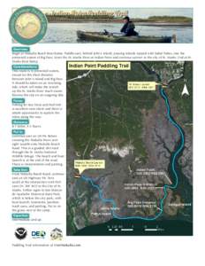
Indian Point Paddling Trail  Overview: Begin at Wakulla Beach Boat Ramp. Paddle east, behind John’s Island, passing islands topped with Sabal Palms, into the protected waters of Big Pass. Enter the St. Marks River at I

Indian Point Paddling Trail Overview: Begin at Wakulla Beach Boat Ramp. Paddle east, behind John’s Island, passing islands topped with Sabal Palms, into the protected waters of Big Pass. Enter the St. Marks River at I

DocID: 1gBkT - View Document

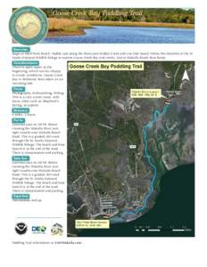
Goose Creek Bay Paddling Trail  Overview: Begin at Shell Point Beach. Paddle east along the shore past Walker Creek and Live Oak Island. Follow the shoreline of the St. Marks National Wildlife Refuge to explore Goose Cre

Goose Creek Bay Paddling Trail Overview: Begin at Shell Point Beach. Paddle east along the shore past Walker Creek and Live Oak Island. Follow the shoreline of the St. Marks National Wildlife Refuge to explore Goose Cre

DocID: 1g84y - View Document

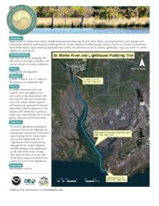
St. Marks River to Lighthouse Paddling Trail  Overview: Begin at the St. Marks Boat Ramp. Paddle downstream following the left (east) bank, passing limestone rock islands and continuous stands of marsh grass bordering th

St. Marks River to Lighthouse Paddling Trail Overview: Begin at the St. Marks Boat Ramp. Paddle downstream following the left (east) bank, passing limestone rock islands and continuous stands of marsh grass bordering th

DocID: 1fAqs - View Document