<--- Back to Details
| First Page | Document Content | |
|---|---|---|
 Date: 2012-08-16 07:20:00Sunshine Coast Queensland Sippy Downs Queensland Buderim Geography of Australia Shire of Maroochy |
Add to Reading List |
 | eldersre.com.auAlexandra Parade, ALEXANDRA HEADLAND Views Forever, Stunning uninterrupted views from Mount Coolum to Point Cartwright! If watching waves breaking on the beach is your passion then have we goDocID: 197EP - View Document |
 | MEDIA STATEMENT Artwork to help clean up the coast Main Roads is calling on volunteer artists to help brighten up Sunshine Coast streets. Main Roads Regional Director Dennis Tennant said the trial project, Sunshine CoastDocID: 195sY - View Document |
 | PDF DocumentDocID: 192ei - View Document |
 | YearIssue 2. Maroochydore 2 (Buderim East) Maroochydore police station: Emergency: 000 . Lesser emergency: Crime stoppers: Free callCash rewards. Kids Help Line: .DocID: 18AHm - View Document |
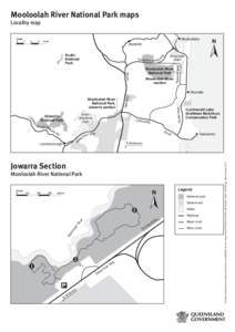
 | Mooloolah River National Park mapsDocID: 18wAl - View Document |
 FIRST OWNERS (…researched by Hessie Lindsell) As the settlers moved north of Caboolture in the 1870s, they selected land suitable for agricultural purposes. This meant the land was used for grazing cattle and horses a